

First released in 2009, this popular application includes data for almost 20,000 hills in the UK and Ireland, plus over 90 lists including …
Munros and Munro Tops, Corbetts, Grahams, Donalds, Furths, Marilyns, Wainwrights and Outlying Fells, Birketts, all County Tops and many more.
For support, PLEASE DO NOT use the App Store as reviews are left anonymously and I have no way of contacting you if I have questions (each message has to go through Apple’s review process, taking days!). Instead, start off with my support page, where known issues and any workarounds are posted as soon as I find out about them. Or contact me directly and you will get a very quick response.
Getting Started


The five icons at the bottom of the screen cover the main ways to interact with the app. From left to right …
- The lists view shows all the lists in the app, and lets you choose the ones you want to track (e.g. Munros, Corbetts, Wainwrights … etc).
- The calendar view shows all ascents recorded in the app. You can also browse all hills by name, distance from your default location, section, height … etc.
- The dashboard view shows bar charts of ascents by month and by year, and lists your most climbed and top unclimbed hills.
- The location view shows a map of the nearest 1000 hills from your default location. This defaults to Fort William, but you can change it using the search icon at the top right.
- The settings view (gear icon) lets you configure the app, and back up your data.
The following sections describe these in more detail.
Lists


By default, five commonly used lists are selected for you: the Munros, the Wainwrights, the Trail 100, and both the Welsh and Irish Furths.
To add, remove or re-order the lists you want to track, select the Edit button. Note that some lists are included multiple times, e.g. you might want to track the Marilyns in Scotland, Wales, England and Ireland separately.
While editing, scroll to the bottom to add up to 3 user defined lists. As an example the built-in Archies are really hills in Scotland with a drop of 100m and a height greater than or equal to 1000m. The new (metric) Grahams are hills in Scotland with a drop of 150m and height range from 600m to 2500ft (or 762m). The old list would have a height range from 2000ft to 2500ft. Once created, user defined lists are tracked like the built in lists.
Totals are shown for each list, e.g. “35/282 (12.4%), 247” means you have climbed 35 out of 282 hills (Munros in this case), with 247 to go.
If you have completed a list and have enabled multiple rounds in the settings (see below), use the control at the top of the screen to switch between lists to be done and those completed. Completed lists are shown with a completion date, e.g. “282 (19/11/2014)”, sorted in date and then list size order (both ascending).
The Map button at the top right shows a map of all (unclimbed/climbed) hills in the lists you are tracking or all unclimbed hills in multiple of your lists (some hills are in more than one list). Climbed hills are shown in blue or green, other hills are shown in red. Tapping each pin lets you name and view each hill. Tap the play icon at the top left to animate the pins in the order climbed. This applies to most map views in the app.
Swipe right to left across a list to show its hills (all or unclimbed) on a map or for more detailed stats.
Tap the lists view icon (bottom left) a second time to quickly sort the lists (manually, or by name, percentage complete, to do/unclimbed counts or year to date progress).
Select a list to show individual hills. Use the menu icon (top left) to filter just those climbed or those left to do. You can sort the list by section/book number, or by name, height, distance from your default location, date climbed or ascents. Also export the selected hills in CSV format, for easy import into a spreadsheet. These options can be accessed more quickly by swiping in from the left.
For Scottish lists, the To Do section header shows separate counts for south and north of the Great Glen, plus the Islands.
The Map button at the top right shows a map of the (possibly filtered) list itself.
Swipe right to left across a hill to show its location on a map.
When on an individual hill, you can add an ascent using the + button (at the bottom), setting the date climbed and adding any notes. To delete an ascent, simply swipe right to left across the date row.
The Map button at the top right shows the hill on a map (shown in grey or purple), together with surrounding hills.
The other icons at the bottom quickly return you to the main (home) screen, link to weather and route and information (for selected hills only), and share your location by email or SMS/text (assumes you are on top of the selected hill).
Ascents and Hills

Here you can view all ascents in the app, sorted by date climbed (most recent first). Using the control at the top of the screen, you can also browse all hills in the app (sorted by name) or all nearby hills (sorted by distance from your default location).
Use the menu icon (top left) to filter just those climbed or those left to do. You can sort by section/book number, or by name, height, distance from your default location, date climbed or ascents. Also export the selected hills in CSV format, for easy import into a spreadsheet or to hill-bagging.co.uk. These options can be accessed more quickly by swiping in from the left.
The Map button at the top right shows a map of all unclimbed hills nearby or all climbed hills. If there are too many hills, panning the map updates the hills shown.
Swipe right to left across a hill to show it on a map.
Selecting a hill takes you to the same individual hill view as described above.
Dashboard
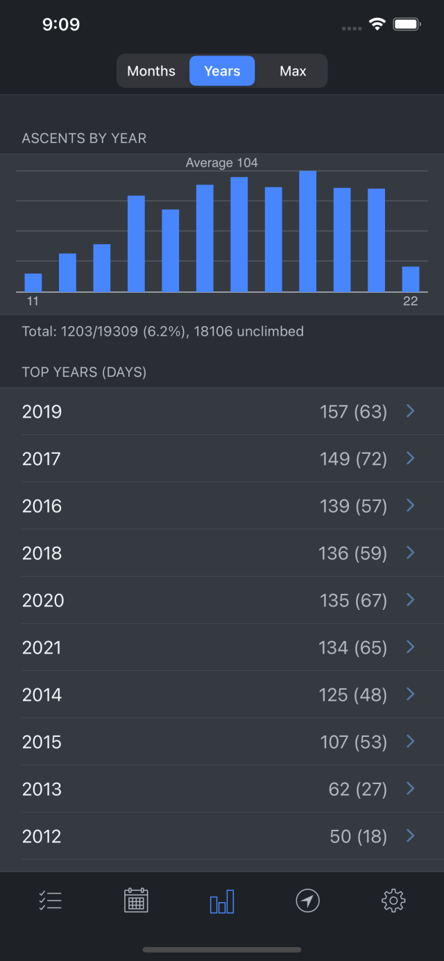
The statistics dashboard shows a bar chart of ascents broken down by month or years. If you have more than 12 years of recorded ascents, the Max option at the top will show all years.
Swipe right to left across a month or year to quickly show a map of ascents for that period or for more detailed stats.
If you have recorded multiple ascents of any given hill, these are shown in descending order, most popular first.
Your top unclimbed hills (tracked lists only) are also shown in decreasing priority order. A hill in multiple lists or one which is close to completing a list is considered higher priority.
Swipe right to left across a hill to quickly add a new ascent for yesterday or today, or show it on a map.
Location


The location view shows a map of the nearest 1000 hills from your default location. Panning the map updates the hills shown. Climbed hills are shown in blue or green, and other hills are shown in red (if they are in your tracked lists) or grey (otherwise).
Use the menu icon (top left) to filter the surrounding hills by height (3000ft, 2500ft or 2000ft), drop (150m, 100m or 30m) or Landranger 1:50k map sheets. Depending on your location, this can sometimes show 2 or even 3 sheets together.
Use the search icon (top right) to set your default location. You can either search for a place (by name or postcode) or simply use the centre of the map.
If you agree to the disclaimer in the settings (see below) you can get the device to locate itself (i.e. use your current location). While locating, the current accuracy is shown, together with the nearest hill, distance and summit feature (useful if the cloud is down!). When it is good enough, select Save.
Tap the location view icon (at the bottom) a second time to quickly locate yourself as above.
Settings


Use the gear icon and choose Settings (at the top) to configure various application settings.
Four overall colour themes are supported, the default or classic white and blue (from iOS 7), a darker blue (and white), dark everywhere and full night mode (black and blue).
You can set preferences for sorting lists (manually, or by name, percentage complete, to do/unclimbed counts or year to date progress), maps (Apple or Google), the pin colour for climbed hills (blue or green), and units (miles or kilometres, feet or metres). I recommend using Google maps as it supports terrain view, great for hills and contours!
Set an email address for exporting backups and CSV files (usually your own), and an email address and phone number for sharing your location information (typically a partners).
Enabling the icon badge will display a count of your unclimbed hills on the application icon (similar to your unread emails).
Multiple rounds lets you track completed lists multiple times. Note that a second round is all the hills twice, and can start before the first round is finished.
Finally, the app can use your device’s location. Once you agree to the disclaimer (that it is not to be relied on for navigation purposes!), the maps will show your current location and the device can locate itself (when setting your default location).
Backups
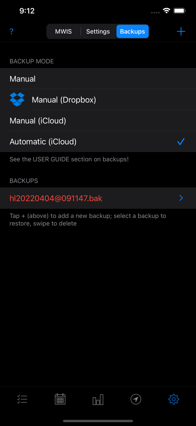
Use the gear icon and choose Backups (at the top) to make and/or restore backups of your data.
The backups feature is a more flexible and reliable way of protecting your data than using a full device backup (e.g. to iCloud). Should the worst happen, it is very easy to import and restore (a backup).
To make a new (manual) backup, select the + button (top right) and an entry will be added to the list of files displayed. Backups are shown in reverse date order (most recent first), and the date and time they were made is included in their names …
hlYYYYMMDD@HHMMSS.bak
To delete a backup, swipe across it from right to left and select Delete.
Exporting Backups
A backup on a single device won’t protect you fully, e.g. you might lose your device or need to restore it to factory settings (e.g. if there is a hardware fault). Also if you delete the app (possibly by accident), all of your backup files will be deleted too. It is therefore very important to export your backups off your device.
On the backups screen, you can choose to have new manual backups copied to either Dropbox or iCloud. Turn this on and all new backups will be exported automatically.
If a backup file is on your device, you can select and export it by AirDrop (to a nearby device), Email or via a number of other apps.
Any backups shown in red are probably not on Dropbox/iCloud. To manually copy a backup, select it and choose the Copy option.
Automatic Backups
By far the easiest way of exporting is to use automatic backups (on the backups screen). Your ascents are monitored and if there are changes, a new backup is made and copied to iCloud when you close the app.
Note that the automatic backups feature also removes older backups, only keeping the 5 most recent.
Importing/Restoring Backups
If the file is already there in the app, go to the backups screen, select it and choose the Restore option.
If it is only on Dropbox or iCloud, choose the same backup setting (i.e. Dropbox or iCloud), go to the backups screen and the file should be visible. Select the backup to restore it.
If it is in an email, select the attachment and open it in Hill Lists.
If it is on another device, use the Export by Airdrop option (on the other device).
Multiple Devices
To use the app on multiple devices, I recommend using automatic backups on your main device only. Then always use that device to edit or add ascents.
If you then configure other devices to use Manual (iCloud) backups, they will see any new backups from your main device and prompt you to restore them.
While it is possible to use automatic backups on all devices and to add ascents from anywhere, you have to be really careful. iCloud can be very slow to update and you might not be editing your latest data.
CSV Import
If you have logged ascents on the Hill Bagging site or elsewhere, you can now import these directly into the app using a file in CSV format (comma separated values). Note that I recommend making a backup (see above) before making any major changes to your database!
To create a CSV file from Hill Bagging, log in (at the top), select Import/Export (top right), then “Export (Downloads)” then use the “export/download a CSV file” link.
Alternatively, create your own CSV file (in plain text format), with one ascent per row, each with three columns: the DoBIH hill identifier, a date in yyyy-MM-dd or dd/MM/yyyy format (or leave blank), and any notes/log (again you can leave this blank). An example row might be …
278,2014-08-27,First time up the UK’s highest mountain, via the CMD arete!
An unknown ascent of Ben Nevis with no log would be …
278,,
Once you have a CSV file in the right format, get the file onto your device (see examples below) then select it and choose Copy to Hill Lists. My app will launch and you will be prompted to import the file.
If you email the file to yourself, use your email application (on your iPhone or iPad), find the attachment, select it and choose Copy to Hill Lists.
If using the Dropbox app, find and select the file, choose the elipses (…), then Export, then Open In …, then Copy to Hill Lists.
Other apps should support a similar export/open in/copy option.
Data, Route and Weather Information
The data for the UK and Ireland has been extracted from version 18.4 of the Database of British and Irish Hills, with kind permission from Chris Crocker and Alan Dawson. I would also like to thank Simon Stewart from MountainViews for supporting a merge of their database into the DoBIH – this makes it so much easier behind the scenes!
Route information for the Munros, Corbetts, most of the Grahams, Donalds, Wainwrights, Hewitts and most of the Trail 100 is provided via external links to the Walk Highlands website.
Route information for most of the hills in Ireland is provided via external links to the MountainViews website.
Weather information for Scotland, England and Wales is provided by the MWIS website.
Many thanks to Chris and Alan for making the application more useful than it would have been without their permission(!). Also to Paul Webster for providing links to the Walk Highlands website, to Simon Stewart for providing links to the MountainViews website, to Geoff Monk for help with integrating MWIS, to Mark Brennan for providing useful feedback on Ireland, and to Simon Edwardes for help on the Hill Bagging import format.
Section Numbers, Regions and Areas
The Database of British and Irish Hills divides the hills into sections, initially starting off with the original 17 sections in the Munro list, and extending this up to section 28 to cover the rest of Scotland. Section 29 is the Isle of Man, sections 30-32 are Wales, sections 33-42 are England, sections 43-56 are Ireland and section 57 is the Channel Islands.
By default, the lists are all arranged by section number, except the Grahams which are arranged by region (1-10) and the Wainwrights which are arranged by book (1-7).
Lists
The following sections describe each of the lists (in alphabetical order).
Archies
Scottish hills at least 1000 metres high with a drop of at least 100 metres on all sides. The Archies are a subset of the Scottish Humps, as published in The Archies: Scotland’s 1000 metre mountains by Paul Fettes (2017). The ARCHIE Mountain Challenge in aid of the ARCHIE Foundation took place over 16 days in 2015.
Arderins
Hills in Ireland at least 500 metres high with a drop of at least 30m on all sides. The list was compiled in 2002 by Simon Stewart in MountainViews and named in 2009.
Binnions
Hills in Ireland under 400m metres high with a drop of at least 100 metres on all sides.
Birketts
Lake District hills over 1,000ft listed in Bill Birkett’s Complete Lakeland Fells.
Bridges
Hills in England, Wales and the Isle of Man at least 2000 feet high as published in The Mountains of England and Wales by George Bridge (1973).
Buxton and Lewis
Hills in England, Wales and the Isle of Man at least 2000 feet high as published in Mountain Summits of England and Wales by Chris Buxton and Gwyn Lewis (1986).
Carns
Hills in Ireland between 400 and 499.9m high with a drop of at least 30m on all sides as defined by MountainViews.
Corbetts and Corbett Tops
Scottish hills between 2500 and 2999 feet high with a drop of at least 500 feet (152.4m) on all sides.
Tops are subsidiary summits of Munros and Corbetts between 2500 and 2999 feet high with a drop of at least 30 metres on all sides.
County Tops
The highest point within (or sometimes on) the boundary of each county.
County boundaries change over time. There are three different county tops lists, covering the traditional historic counties (suffixed H), the more recent mixtures of administrative areas (A) and the current county and unitary authority tops (C).
Deweys, Donald Deweys and Highland Fives
Hills in England, Wales and the Isle of Man at least 500m high and below 609.6m with a drop of at least 30m on all sides. Equivalent lists offered by the DoBIH are the Donald Deweys in the Scottish Lowlands and the Highland Fives in the Scottish Highlands, the latter having a lower upper limit of 600m (in tandem with the Graham Tops).
Dillons
Hills in Ireland at least 2000 feet high as published in The Mountains of Ireland by Paddy Dillon (2013).
Dodds
Hills in Scotland, England, Wales, the Isle of Man and Ireland between 500m and 599.9m high with a drop of at least 30 metres on all sides.
Donalds, Donald Tops and New Donalds
Hills in the Scottish Lowlands at least 2000 feet high.
Tops are all elevations with a drop of at least 100 feet (30.48m) on all sides and elevations of sufficient topographical merit with a drop of between 50 and 100 feet.
A related list is Dawson’s New Donalds, in which the qualifying criterion is simplified to 30 metres of drop. The New Donalds are a subset of the Donalds and Donald Tops.
The Donalds (SMC) list combines the Donalds and the Donald Tops.
Ethels
A list of 95 summits in the Peak District, named as a tribute to Ethel Haythornthwaite who was a prime mover behind the establishment of the Peak District as Britain’s first national park in 1951.
Fellrangers
Lake District hills in a set of eight volumes authored by Mark Richards and inspired by the Wainwright guides.
Full House
A combination of all the SMC lists: Munros, Munro Tops, Corbetts, Grahams, Donalds, Donald Tops and Furths.
Furths
Hills in Wales, England and Ireland over 3000ft.
The Furths (SMC) list combines the Welsh, English and Irish Furths.
Grahams and Graham Tops
Scottish hills at least 600 metres high and below 762 metres (2500 feet) and with a drop of at least 150 metres on all sides (the lower limit was reduced from 2000 feet in November 2022, adding 12 hills).
Tops are subsidiary summits of Munros, Corbetts and Grahams between 600 and 762 metres high with a drop of at least 30 metres on all sides.
Hewitts
Hills in England, Wales and Ireland at least 2000 feet high with a drop of at least 30 metres on all sides.
High Hills of Britain
Hills in the book The 1033 High Hills of Britain by Alan Dawson (2021). Now 1035 hills!
Humps
British and Irish hills of any height with a drop of at least 100 metres or more on all sides. The name Hump stands for Hundred Metre Prominence.
London Boroughs
London Borough tops.
Marilyns
British and Irish hills of any height with a drop of at least 150 metres on all sides. The geographical area includes the Isle of Man and the islands of St Kilda.
Munros and Munro Tops
Scottish hills at least 3000 feet in height regarded by the SMC as distinct and separate mountains, based on Sir Hugh Munro’s list originally published in 1891.
All historical variations of the Munros list are also included: 1891 (the original), 1921, 1933, 1953, 1969, 1974, 1981, 1984, 1990 and 1997. Also a list of deleted Munros, i.e. hills that used to be included in one of the historical lists but are no longer classified as Munros.
Subsidiary summits meeting the height criterion are designated Munro Tops.
Deleted Munro Tops include the deleted Munros, Beinn an Lochain, Sgurr nan Ceannaichean and Beinn a’ Chlaidheimh.
Murdos
Scottish hills at least 3000 feet in height with a drop of at least 30 metres on all sides. All Murdos are also Munro Tops but some Munro Tops fail to qualify as Murdos.
Nuttalls
Hills in England and Wales at least 2000 feet high with a drop of at least 15 metres on all sides, as published in The Mountains of England and Wales. The list includes 127 summits that do not qualify as Hewitts.
SIBs
The Significant Islands of Britain are defined as “naturally occurring land, which at MHWS is shown on available OS mapping to be completely surrounded by water, with either an area of at least 30 hectares within the MHWS contour line or an ‘easily accessed’ summit prominence of at least 30 metres above MSL, all man-made links and structures being discounted”.
Simms
Hills at least 600m high with a drop of at least 30 metres on all sides.
Synges
Lake District hills over 1,000ft, as published in The Synges (2025). This is a revised version of The Lakeland Summits: Survey of the Fells of the Lake District National Park by Timothy Synge (1995).
TGO 40s
A list of Britain’s 40 “finest” hills, plus a further 10 in Ireland, as published by The Great Outdoors Magazine (2018).
Trail 100s
A list of 100 hills published in Trail Magazine (2007) which has become popularised by becoming the objective of the WaterAid Trail 100 charity challenge.
Tumps
The Tumps (Thirty and Upward Metre Prominences) comprise all the hills of Britain with 30m or more of drop, with no minimum height. Thus it incorporates a number of other hill lists. The Tumps currently comprise over 17,000 hills and are a well established bagging objective.
Vandeleur-Lynams
Hills in Ireland at least 600 metres high with a drop of at least 15 metres on all sides.
Wainwrights and Outlying Fells
Wainwrights are the 214 hills listed in books 1-7 of Wainwright’s A Pictorial Guide to the Lakeland Fells.
The Outlying Fells are those hills listed in The Outlying Fells of Lakeland.
